| |
|
|
 |

 District Profile District Profile |
Location
Chittoor district is situated between 120 – 37” to 140-8” North Latitude and 780-33” to 790-55” East Longitude.
Population
The population of the district is 37.45 lakhs with a density of 246 per Sq.km. There are 5.28 lakh cultivators and 6.29 lakh agricultural labourers in the district as per 2001 census.
Table – 1: Socio-economic and technological profile of the District
|
| Socio-economic and technological profile of the District |
| Total no. of mandals in the district |
66 |
| Total no. of revenue villages in each mandal |
1580 |
| Total population of the district |
37,45,875 |
| Literacy rate |
66.80 |
| Rural population in the district |
29,34,845 |
| Rural population as % to Total Population |
78.30 |
| Marginal farmers (< 2.47 acres) |
2,78,443 |
| Small farmers (2.47 – 4.93 acres) |
1,11,676 |
| Other farmers (4.94 acres & above) |
86,738 |
| Geographical area of the district (ha) |
14,98,778 |
Agro-Climatic Zone
The district is categorized under Southern Agro climatic zone of Andhra Pradesh based on soil type, rainfall and altitude. Groundnut cropping system occupies maximum area of the zone followed by Rice. In dry farming tract of the zone, mono cropping of the Groundnut is the main stay whereas under canals, tanks, wells and bore wells, double cropping is practiced.
Rainfall
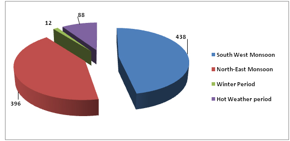
The District has the benefit of receiving rainfall during both the South West and North East Monsoon periods. While the normal rainfall of the District for the South West Monsoon period is 438.00 mm that for North East Monsoon period is 396.00 mm. The rainfall received during the Winter Period and hot weather period is negligible their respective normals being 12.0 mm and 88.0 mm. The Annual normal rainfall of the District is 934.0 mm.
The rainfall received from the South West Monsoon is more copious compared to North East Monsoon in the Western Mandals and in the Central part of the District, where as the rainfall received from North East Monsoon is comparatively copious in the eastern Mandals of the District.
Normal rainfall pattern in the district (mm)
|
|
|
| Particulars |
Area |
| Forest |
451345 |
| Barren & Uncultivable land |
164265 |
| Land put to Non-agrl. uses |
142242 |
| Permanent pastures & other grazing lands |
36521 |
| Miscellaneous tree crops & groves not included in net area sown |
25173 |
| Cultivable waste |
39512 |
| Other fallow lands |
126287 |
| Current fallows |
161759 |
| Net area sown |
351674 |
| Total geographical area |
1498778 |
| Total cropped area |
390336 |
| Area sown more than once |
36283 |
| Gross Irrigated Area (Ha) |
167676 |
| Net area Irrigated |
131393 |
| Area irrigated more than once |
36283 |
Soils
Red soil occupies major portion of the district

The fertility status of the soils of the district in general is
| Organic matter |
: |
Low |
| Nitrogen |
: |
Low |
| Phosphorous |
: |
Low to Medium |
| Potash |
: |
Medium to High |
| PH |
: |
6.5 to 8.0 |
| Zinc |
: |
Deficiency is identified in all parts of the district |
| Iron |
: |
Deficiency observed in Sugarcane and Groundnut areas |
| E.C |
: |
Normal |
| Water holding capacity |
: |
Low to Moderate |
Farming situations
Farming situation |
Mandals covered |
Crops and cropping pattern |
| Rainfed red soils |
Peddamandyam , Mollakala chervu, Madanapalli, Nimmanapalli, Chowdepalli, Bangarupallem, Chittoor, Yadamari, G.D Nellore, Palasamudram, Palamaneru, |
Groundnut +Redgram
Bajra
Rainfed Tomato |
Canals (Araniyar,
Swarnamukhi, Ayacut area) |
Srikalahasti, Thotambedu, B.N.Kandriga , Yerpedu, Narayanavanam, Puttur, Nagiri, Vedurukuppam |
Rice- groundnut,
Sugarcane, Sunflower
Bajra
Vegetables |
| Rain fed tanks/ Bore wells |
Tamballapalli, PTM, Ramasamudram, B.Kothakota, Punganoor, V.kota, S.RPuram Santhipuram, Ramakuppam, Gudipala, Tavanampalli, Penumuru, Karvetinagaram, Vijayapuram |
Ground nut, Rice,
Tomato, Maize, Sunflower |
| Wells / bore wells |
Kurabalakota, Guramkonda, Peddapanjani, Gangavaram, Somala, Sadum, Pulicherlla, Gudipalli, Kuppam, Puthalapattu, Irala, Pakala, Chandragiri, Renigunta, KVBpuram, Varadayapalem, Nindra, Pichatur, Nagalapuram |
Rice, Groundnut, Tomato, Jowar,
Maize,
Vegetables |
| Horticulture crops |
Kuppam,Madanapalli, Mollakalachervu, Satyavedu, RCPuram, Tirupati, Kalakada, Valmikipuram, Kalikiri, Chinnagottigallu, Ropicherla |
Mango, Cashew, Papaya, Vegetables, flowers, Banana |
Area, Production and Productivity of major crops
Crop |
Kharif |
Rabi |
Area(ha) |
Production (MTs) |
Productivity (Kg/ha) |
Area(ha) |
Production (tons) |
Productivity (Kg/ha) |
| Paddy |
16224 |
52728 |
3250 |
43240 |
142692 |
3300 |
| Jowar |
1363 |
874 |
641 |
- |
- |
- |
| Bajra |
3048 |
8885 |
2915 |
- |
- |
- |
| Maize |
969 |
5814 |
6000 |
625 |
3760 |
6000 |
| Ragi |
6978 |
13956 |
2000 |
844 |
1772 |
2100 |
| Minor millets |
312 |
218 |
700 |
|
|
|
| Red gram |
11218 |
5609 |
500 |
|
|
|
| Horse gram |
2131 |
1236 |
580 |
1702 |
1277 |
750 |
| Green gram |
838 |
272 |
325 |
402 |
221 |
550 |
| Black gram |
656 |
246 |
375 |
1164 |
757 |
650 |
| Cow pea |
1367 |
376 |
275 |
- |
- |
- |
| Other pulses |
2255 |
1015 |
450 |
|
|
|
| Groundnut |
148203 |
177844 |
1200 |
13653 |
33859 |
2480 |
| Sunflower |
534 |
988 |
1850 |
1090 |
2267 |
2080 |
| Sesamum |
198 |
42 |
210 |
314 |
212 |
676 |
| Castor |
164 |
107 |
650 |
- |
- |
- |
| Chillies |
474 |
1683 |
3550 |
- |
- |
- |
| Sugarcane |
26525 |
1989375 |
75000 |
- |
- |
- |
| Onion |
156 |
2371 |
15200 |
- |
- |
- |
AREA, PRODUCTION AND PRODUCTIVITY OF HORTICULTURE CROPS
IN CHITTOOR DISTRICT
Name of the Crop |
Area
(Ha) |
Production
(M.T) |
Productivity
(T/Ha ) |
| Mango |
60407 |
483256 |
8 |
| Lemon (Lime & Other Citrus Fruits |
232 |
3202 |
14 |
| Banana |
1100 |
25300 |
23 |
| Tomato |
14588 |
262584 |
18 |
| Potato |
1892 |
30272 |
16 |
| Beans |
1424 |
8544 |
6 |
| Brinjal |
1677 |
33540 |
20 |
| coconut |
4165 |
31.934 |
|
| Chillies |
3242 |
7781 |
3 |
| Tamarind |
2499 |
24990 |
10 |
| Chrysanthemum |
355 |
3550 |
10 |
| Crossandra |
385 |
1155 |
3 |
| Jasmine |
478 |
1912 |
4 |
| Marigold |
261 |
1305 |
5 |
LIVESTOCK & POULTRY POPULATION
| Cattle |
1104349 |
| Buffaloes |
139759 |
| Sheep |
1124890 |
| Goat |
490931 |
| Pigs |
7208 |
| Poultry |
14398793 |
|
| |
|
 |
|
|